
View Our Recent Work:

Most boaters assume nav electronics explained means understanding how to read a GPS screen. That assumption is costly. Modern marine navigation electronics are an integrated web of sensors, receivers, digital chart systems, radar, and vessel identification tools that work together to keep you safe offshore. Getting any one piece wrong, whether that is the antenna placement, network wiring, or system redundancy, can compromise everything. This article breaks down navigation electronics from the hardware up so you can manage your vessel with real confidence, not just a glowing screen at the helm.
Table of Contents
- Key Takeaways
- Nav electronics explained: core hardware components
- Key navigation systems integrated on your vessel
- Safety and redundancy: what can go wrong
- Network integration and troubleshooting onboard
- My honest take on nav electronics readiness
- How Mazzamarine supports your nav electronics
- FAQ
Key Takeaways
| Point | Details |
|---|---|
| Nav electronics are a system, not a device | GPS is one input; radar, AIS, ECDIS, and INS complete the picture for true situational awareness. |
| Hardware quality drives accuracy | Antenna quality and placement determine system performance more than software settings ever will. |
| ECDIS and ECS are not interchangeable | Only ECDIS meets the IEC 61174 standard required under SOLAS; ECS is not a legal substitute. |
| Redundancy is not optional | GPS vulnerabilities like jamming and spoofing make paper charts and traditional skills a genuine safety requirement. |
| Network wiring determines reliability | NMEA 2000 termination errors cause more system failures than device faults do. |
Nav electronics explained: core hardware components
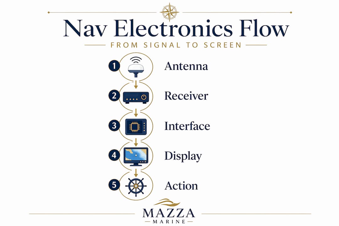
When people talk about what is navigation electronics at a foundational level, the conversation starts with the signal chain. Your GPS does not just “receive GPS.” It runs a complex signal chain involving a GNSS antenna, a low-noise amplifier, an RF downconverter, code tracking loops, and a processor running algorithms like Kalman filters to compute your actual position. Each stage matters.
The antenna captures satellite signals and sends them down the coax to the receiver. The low-noise amplifier boosts those signals without adding significant interference. The receiver then strips out the code from the carrier wave and compares timing data from multiple satellites to triangulate your position. Consumer-grade receivers and marine-grade receivers use the same fundamental process, but marine units are built to handle vibration, salt air, and the continuous duty cycles boats demand.
| Component | Function |
|---|---|
| GNSS Antenna | Captures raw satellite signals and feeds them to the receiver |
| Low-Noise Amplifier | Boosts signal strength with minimal interference added |
| RF Downconverter | Shifts frequency for processing by the digital receiver |
| Processor / Kalman Filter | Computes position, velocity, and time from multiple satellite inputs |
| NMEA Interface | Outputs standardized data to chart plotters, autopilots, and displays |
The two dominant interface standards you will encounter are NMEA 0183 and NMEA 2000. NMEA 0183 is an older serial protocol that sends data point to point, meaning one device talks to one receiver at a time. NMEA 2000 is a CAN bus network where multiple devices share a single backbone, broadcasting data that any connected device can read. Understanding this distinction is critical when you start connecting multiple nav instruments together.
Pro Tip: Never skimp on antenna quality or placement. Software cannot compensate for a poorly placed or low-quality antenna. Mount your GNSS antenna with a clear 360-degree sky view and away from radar units, which can create interference.
Key navigation systems integrated on your vessel
Understanding nav systems means understanding which tools do which job, and how they hand off data to each other. Here is a practical overview of the major categories:
- GNSS with augmentation (WAAS/DGPS): Standard GPS accuracy runs around 3 to 5 meters. Wide Area Augmentation System (WAAS) and Differential GPS (DGPS) pull that down to under 1 meter by referencing fixed ground stations to correct atmospheric error. For coastal navigation near shoals and channels, that margin matters enormously.
- ECDIS vs. ECS: Electronic Chart Display and Information System (ECDIS) is legally required under SOLAS as the equivalent of paper charts for commercial vessels. It must meet the IEC 61174 standard. Electronic Chart Systems (ECS) are the plotters you see on most recreational yachts. They are excellent tools but carry no legal equivalency. Know which one you have.
- Radar (X-band and S-band): X-band radar at 9 GHz gives you high resolution for close-range targets and is ideal for collision avoidance. S-band at 3 GHz penetrates rain and fog more effectively, making it valuable offshore. Many larger vessels carry both.
- AIS (Automatic Identification System): AIS broadcasts and receives identity, position, course, and speed data over two dedicated VHF channels. Dynamic data like position and speed broadcasts every 2 to 10 seconds, while static vessel data updates every 6 minutes. This makes AIS your best real-time picture of vessel traffic around you.
- Inertial Navigation Systems (INS): When GNSS signals degrade or disappear entirely, INS uses accelerometers and gyroscopes to maintain position continuity through dead reckoning. It requires an initial position input and then computes updates autonomously, with no external signal needed.
| AIS Data Type | Broadcast Interval |
|---|---|
| Dynamic (position, speed, course) | Every 2 to 10 seconds |
| Static (vessel name, MMSI, type) | Every 6 minutes |
| Voyage-related (destination, ETA) | Every 6 minutes or on request |
On larger vessels, Integrated Bridge Systems fuse radar, ECDIS, AIS, and additional sensors into a single operator interface. The benefit is genuine: fewer screens, less cognitive load, and faster situational awareness during complex maneuvers.
Pro Tip: Use your AIS display as a collision avoidance planning tool, not just a traffic indicator. Many modern chart plotters allow you to set CPA (Closest Point of Approach) alarms that alert you when a vessel’s projected course will bring it within a defined distance of your position.
Safety and redundancy: what can go wrong
Here is where the navigation technology basics conversation gets uncomfortable. GPS is not infallible. The signals are low-power microwave transmissions that can be jammed or spoofed by everything from military exercises to bad actors near major ports. Solar interference during strong geomagnetic storms can degrade accuracy across entire ocean regions. The US Navy recognized this reality and reinstated celestial navigation training for officers, a decision driven entirely by GPS vulnerability concerns.
Operational competence adds another layer of complexity. Holding an ECDIS certification is not the same as being operationally ready to use the specific system installed on your boat. Training gaps and interface variations between manufacturers create real risks during live navigation. The interface you trained on and the system on your vessel may behave differently in ways that matter when conditions deteriorate.
Best practices for redundancy and safety management:
- Maintain up-to-date paper charts for your primary cruising area. These are your legal and practical fallback.
- Practice basic celestial navigation or at minimum hand-bearing compass bearings on known charted objects.
- Keep a separate handheld GPS unit with fresh batteries aboard, independent of your main power system.
- Log your position manually at least every 30 minutes on longer passages, creating a dead reckoning record.
- Test your AIS transponder regularly by verifying your vessel appears correctly on AIS tracking websites.
- Know your radar’s false echo sources: sea clutter and rain clutter controls are tools, not filters to set and forget.
“The sailors who get into real trouble offshore are rarely the ones without electronics. They are the ones who cannot function without them.”
Pro Tip: Balance technology with traditional skills. Technology supports your seamanship; it does not replace it. Schedule at least one passage per season where you rely primarily on paper charts, compass, and speed-time-distance calculations to keep those skills sharp.
Network integration and troubleshooting onboard
Modern nav electronics for beginners and experienced owners alike share one consistent challenge: getting multiple devices to talk to each other reliably. Most contemporary yachts run a hybrid network with older NMEA 0183 devices alongside newer NMEA 2000 equipment. A gateway device translates between these two protocols, allowing your legacy wind or depth instrument to share data on a modern NMEA 2000 backbone without requiring a full rewiring project.
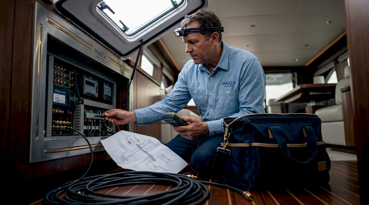
When troubleshooting NMEA 2000 network instability, the cause is almost never the device itself. Incorrect terminator placement and cable length violations are the most common root causes. Every NMEA 2000 backbone requires exactly two terminators, one at each end of the backbone. A missing or misplaced terminator creates signal reflections that corrupt data for every device on the network.
Key points for upgrading or retrofitting your nav network:
- Map your existing devices and identify which use NMEA 0183 output and which use NMEA 2000 before purchasing anything.
- Use a gateway converter at the junction between legacy and modern devices. Quality brands in this space include Actisense and Garmin.
- Keep NMEA 2000 backbone runs within the maximum length specifications for your backbone cable rating. Exceeding cable length degrades signal integrity.
- Label every connector and document your network topology. Troubleshooting an undocumented network on a rainy night is genuinely miserable.
- For nav system improvements on Florida yachts, a structured checklist approach prevents costly missteps when upgrading incrementally.
Pro Tip: When a chart plotter suddenly loses GPS data while other instruments still function, check the NMEA 2000 backbone terminators before assuming the plotter is faulty. Nine times out of ten, a loose T-connector or missing terminator is the culprit.
My honest take on nav electronics readiness
I have spent years working alongside boat owners who spent serious money on navigation systems and still found themselves disoriented at sea. Not because the equipment failed. Because they had never truly learned it under pressure.
In my experience, the biggest gap in most nav setups is not hardware at all. It is familiarity. A $15,000 ECDIS on a vessel whose captain has never deliberately triggered a route deviation alarm, never navigated in radar-only conditions, and never confirmed a position by cross-bearing is a vessel that is quietly underequipped. The certified but not competent problem is real, and it applies to recreational mariners just as much as commercial officers.
What I recommend is simple but takes discipline. Sit at your helm in a marina and deliberately work through every nav screen, every alarm setting, and every data source. Then do it again with a problem: disconnect a sensor and watch how the system responds. That kind of deliberate practice builds the muscle memory that keeps you calm when conditions deteriorate at 2 a.m. offshore. Your electronics are only as strong as your understanding of them.
— Jason
How Mazzamarine supports your nav electronics
Whether you are upgrading a legacy chartplotter, troubleshooting an unstable NMEA 2000 network, or building out a full navigation suite on a new refit, Mazzamarine has the Florida-based expertise to do the work right. Mino and Luigi’s team works with a network of vetted marine electronics specialists who understand the specific demands of South Florida waters.
From electrical and nav system work to full yacht refits, Mazzamarine handles everything as a single point of coordination. No hunting down separate contractors, no communication gaps between an electrician and a systems integrator. If your vessel is showing signs of electronics issues or you want a professional assessment before upgrading, start with the yacht repair signs guide to understand where your priorities should be. And if you are thinking about a broader electronics and lighting overhaul, explore marine electrical upgrades tailored to Florida yacht owners. Contact the Mazzamarine team and get a consultation from people who genuinely love this work.
FAQ
What is navigation electronics on a boat?
Navigation electronics include every onboard electronic system used to determine position, plot courses, monitor vessel traffic, and maintain situational awareness. This covers GPS receivers, chart plotters, radar, AIS transponders, depth sounders, and electronic chart systems.
How does GPS work on a marine vessel?
Marine GPS receivers capture signals from multiple satellites and use timing differences to calculate position through a signal chain that includes antenna capture, amplification, downconversion, and processor computation via algorithms like Kalman filters.
What is the difference between ECDIS and ECS?
ECDIS meets the IEC 61174 standard and is legally equivalent to paper charts under SOLAS for commercial vessels. ECS (Electronic Chart Systems) are the chart plotters used on recreational boats and do not carry that legal equivalency.
Why does my NMEA 2000 network keep losing devices?
The most common cause is incorrect terminator placement or missing terminators on the CAN bus backbone. Every NMEA 2000 network requires exactly two terminators, one at each physical end of the backbone cable.
Do I still need paper charts if I have good electronics?
Yes. GPS and electronic chart systems are vulnerable to jamming, spoofing, and power failure. Paper charts and traditional navigation skills remain a genuine safety requirement, not just a formality.
Recommended
Text or Call 954-330-9653 Schedule Appointment
Mazza Marine Yacht Services & Refit

Fiberglass Upgrades and Damage Repair

Premium Yacht Paint/ Faux Teak

Fishing: Custom Rods, Reels,Tackle

Electrical, Electronics and Navigation

Paint, Hull and Gelcoat

Teak Decks, Wood Cabinets, Carpentry

Canvas, Enclosures and Upholstery

Mechanical, Repower and Running Gear

Plumbing, Bilge and Thru-Hulls

Welding and Custom Fabrication

Interior Refit And Past Work
Get your yacht value Estimate
"*" indicates required fields